Video über BIM für Vermessung, Planung und Bau von Infrastrukturprojekten
SierraSoft ist ein Unternehmen, das sich auf die Entwicklung und Bereitstellung von BIM-Software für Vermessung und Infrastrukturplanung spezialisiert hat
Video über BIM für die Vermessung, Video über BIM für Eisenbahn-, Straßen- und Wasserbauplanung, BIM-Software für das Bauwesen
Video über BIM im Bauwesen, Video über BIM für Infrastrukturplanungen, Video über BIM für die Vermessung
Video SierraSoft
Video über BIM für Vermessung, Planung und Bau von Infrastrukturprojekten
BIM für Vermessung und Infrastrukturplanung
Anwendung der Methodik des Building Information Modeling auf Vermessungen und Infrastrukturplanungen im Verkehrswesen
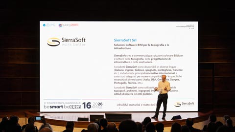
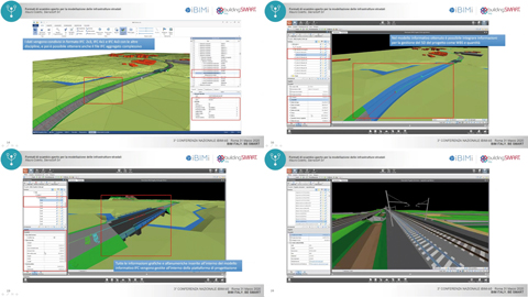
infraBIM: maturità e stato dell'arte
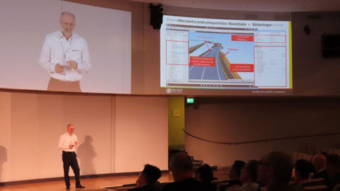
Keynote by Mauro Coletto (CEO of SierraSoft) at the 9th IBIMI National Conference - buildingSMART Italia
Sehen Sie sich das Video an >
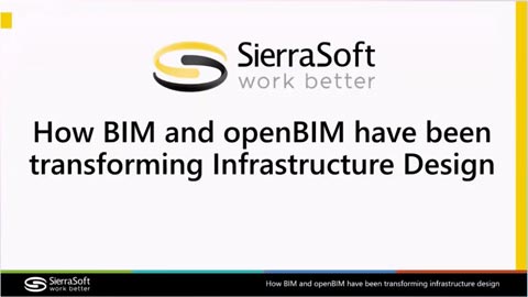
How BIM and openBIM have been transforming Infrastructure Design
Speech by Mauro Coletto (CEO of SierraSoft) at the buildingSMART International Standards Summit – Berlin 2025
Sehen Sie sich das Video an >
Verification of regulatory, functional, and safety compliance of a road through IFC 4.3 models
Speech by Mauro Coletto (CEO of SierraSoft) at the buildingSMART International Standards Summit – Berlin 2025
Sehen Sie sich das Video an >
Using IDS and bSDD to optimize infrastructure design
Speech by Mauro Coletto (CEO of SierraSoft) at the buildingSMART International Standards Summit – Valencia 2024
Sehen Sie sich das Video an >
Validazione delle infrastrutture stradali utilizzando il formato IFC 4.3
Keynote by Mauro Coletto (CEO of SierraSoft) at the 8th IBIMI National Conference - buildingSMART Italia
Sehen Sie sich das Video an >
Verification of regulatory, functional, and safety compliance of a road through IFC 4.3 models
Speech by Mauro Coletto (CEO of SierraSoft) at the buildingSMART International Standards Summit – Berlin 2025
Sehen Sie sich das Video an >
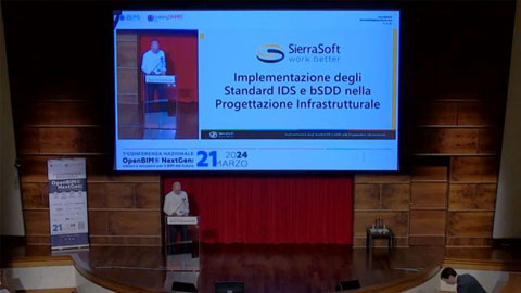
Implementazione degli Standard IDS e bSDD nella Progettazione Infrastrutturale
Keynote von Mauro Coletto (CEO von SierraSoft) auf 7° Conferenza Nazionale IBIMI - buildingSMART Italia
Sehen Sie sich das Video an >
InfraBIM with openBIM is already here
Rede von Mauro Coletto (SierraSoft) auf dem buildingSMART International Standards Summit in Rom - 2023
Sehen Sie sich das Video an >
Sinnvolle Modelle mit SierraSoft BIM-Modeling
Beispiel für die Verwendung von BIM-Filtern, um Informationsmodelle für einen bestimmten Verwendungszweck zu erstellen (Video in Englisch)
Sehen Sie sich das Video an >
Informationsaustausch von Massen aus Modellen mit SierraSoft BIM-Modeling
Beispiel für den Export von Massen in das BIM-Modell
Sehen Sie sich das Video an >
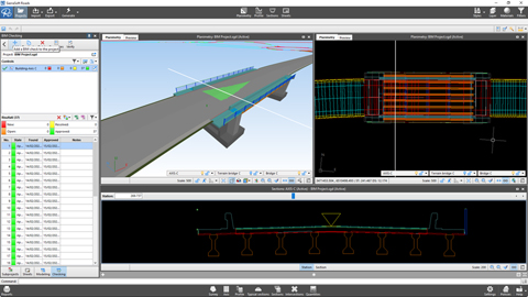
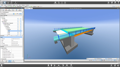
Informationsaustausch einer Struktur mit SierraSoft BIM-Exchange und SierraSoft BIM-Checking
Beispiel für einen Arbeitsablauf zum Einfügen einer Brücke in die Planung
Sehen Sie sich das Video an >
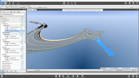
Informationsaustausch einer Vermessung mit SierraSoft BIM-Exchange und SierraSoft BIM-Checking
Beispiel für den Arbeitsablauf zwischen einer BIM-Vermessung und einer Planung
Sehen Sie sich das Video an >
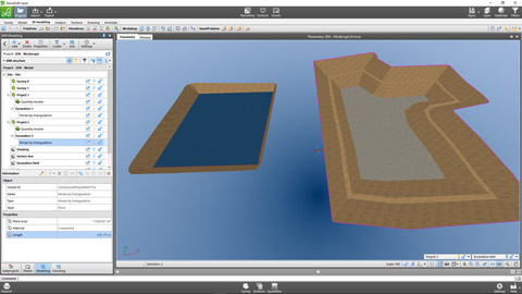
Erstellung des Informationsmodells eines Rohrnetzes mit SierraSoft BIM-Modeling
Beispiel für die Erstellung eines Informationsmodells für ein Rohrnetz
Sehen Sie sich das Video an >
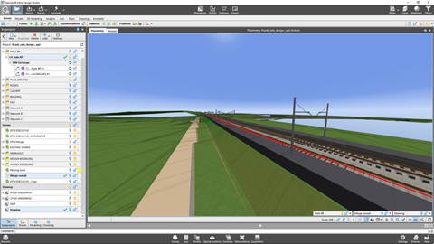
Erstellung eines Informationsmodells einer Bahntrasse mit SierraSoft BIM-Modeling
Beispiel für die Erstellung eines Informationsmodells für eine Bahnstrecke
Sehen Sie sich das Video an >
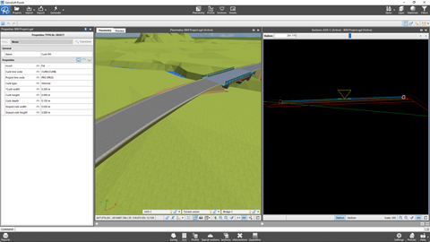
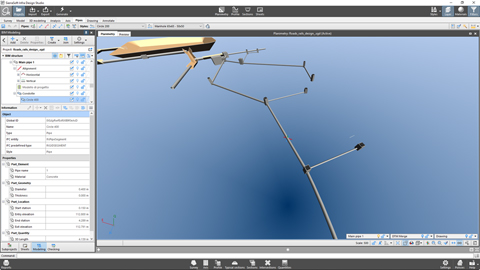
Erstellung eines Informationsmodells für Straßen mit SierraSoft BIM-Modeling
Beispiel für die Erstellung eines Informationsmodells für eine Straße
Sehen Sie sich das Video an >
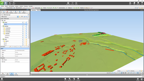
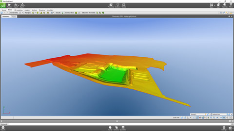
Erstellung eines Informationsmodells des Geländes mit SierraSoft BIM-Modeling
Beispiel für die Erstellung eines Informationsmodells ausgehend von einer Karte
Sehen Sie sich das Video an >
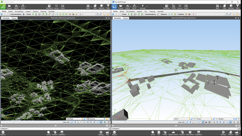
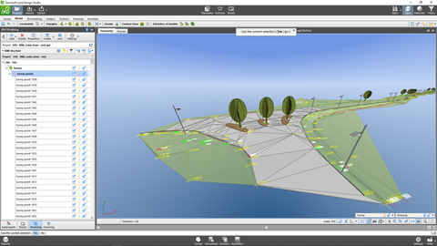
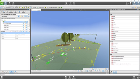
Erstellung eines Informationsmodells der Vermessung mit SierraSoft BIM-Modeling
Beispiel für die Erstellung eines Informationsmodells für Vermessungen
Sehen Sie sich das Video an >
The road and railway infrastructure designer in BIM: evolution of a profession
Speech by Mauro Coletto (SierraSoft) - ASSOBIM Talks of 18 may 2023
Sehen Sie sich das Video an >
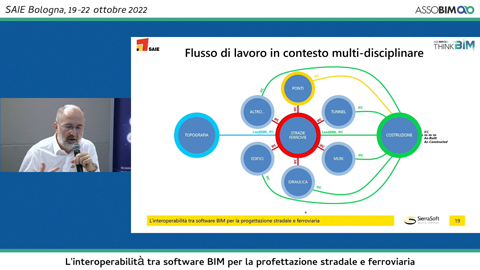
Effizienz und Qualität bei der BIM-Planung von Straßen und Schienenwegen
Vortrag von Mauro Coletto (SierraSoft) - ASSOBIM-Gespräche vom 14. Dezember 2022 (Video in Italienisch)
Sehen Sie sich das Video an >
Interoperabilität zwischen BIM-Software für die Planung von Straßen und Schienenwegen
Vortrag von Mauro Coletto (SierraSoft) - Digitization Village by Assobim - SAIE 2022 (Video in Italienisch)
Sehen Sie sich das Video an >
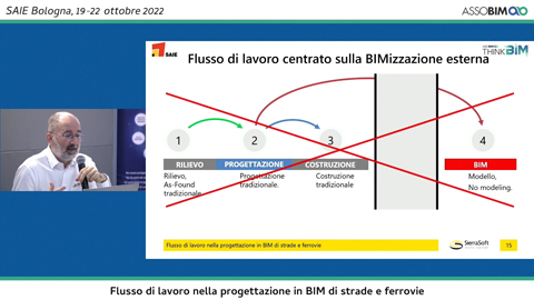
BIM-Workflow für die Planung von Straßen und Schienenwegen
Vortrag von Mauro Coletto (SierraSoft) - Digitization Village by Assobim - SAIE 2022 (Video in Italienisch)
Sehen Sie sich das Video an >
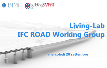
Living-Lab IFC Arbeitsgruppe Straße
Präsentation des “Guida all'IFC per il progetto stradale” der aus den Aktivitäten der Arbeitsgruppe IFC Road von IBIMI - buildingSMART Italia resultiert (Video in Italienisch)
Sehen Sie sich das Video an >
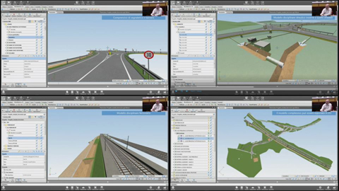
Informationsmodellierung von Straßen und Eisenbahnen in IFC mit SierraSoft Infra Design Studio
Vortrag von Mauro Coletto (SierraSoft) während der 5. nationalen Konferenz von IBIMI - buildingSMART Italia (Video in Italienisch)
Sehen Sie sich das Video an >
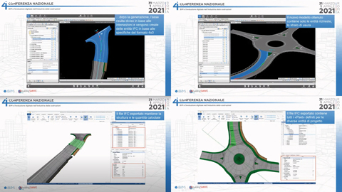
Die Planung von Straßeninfrastrukturen mit IFC
Speech by Mauro Coletto (SierraSoft) during the 4th National Conference of IBIVortrag von Mauro Coletto (SierraSoft) während der 4. nationalen Konferenz von IBIMI - buildingSMART ItaliaMI - buildingSMART Italia (Video in Italienisch)
Sehen Sie sich das Video an >
Offene Austauschformate für die Modellierung der Infrastrukturplanung im Straßenbau
Vortrag von Mauro Coletto (SierraSoft) während der 3. nationalen Konferenz von IBIMI - buildingSMART Italia (Video in Italienisch)
Sehen Sie sich das Video an >
BIM-Software für 3D-Modellierung und Analyse
SierraSoft Land è un software BIM per la modellazione 3D e l'analisi del territorio da punti rilevati con stazione totale, GPS, laser scanner, droni.
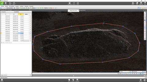
Vermessung mit BIM mit SierraSoft Land
Beispiel für die automatische Anpassung einer Vermessung mit Hilfe von Codes, die während der Messung im Gelände zugewiesen wurden, durch BIM (Video in Englisch)
Sehen Sie sich das Video an >
Modellierung und Massenermittlung und BIM mit SierraSoft Land
Modellierungsbeispiel, Schnitte extrahieren und Massen berechnen (Video in Englisch)
Sehen Sie sich das Video an >
3D-Planung mit BIM und SierraSoft Land
Beispiel einer 3D Planung mit Smart-Polylinie, Massenberechnung und Verschmelzung von Modellen (Video in Englisch)
Sehen Sie sich das Video an >
Verwaltung von Punktwolken mit SierraSoft Land
Beispiel für die Modellierung und Berechnung von Massen aus Punktwolken (Video in Englisch)
Sehen Sie sich das Video an >
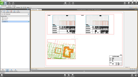
Pläne in BIM mit SierraSoft Land
Datenausdrucke und Verwaltung von Planbeschriftungen und -blättern für die Erstellung von Zeichnungsunterlagen mit Anbindung an das Projektinformationsmodell (Video in Englisch)
Sehen Sie sich das Video an >
BIM-Software für die hydraulische Planung
SierraSoft Hydro ist eine BIM-Software für die hydraulische Planung von Wasserstraßen, Kanälen, Gräben, Rohren, Rohrnetzen und Schächten.
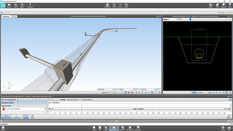
Hydraulische BIM Planung eines Leitungssystems mit SierraSoft Hydro
Beispiel für die Planung einer Hydraulikleitung unterhalb einer Straße (Video in Englisch)
Sehen Sie sich das Video an >
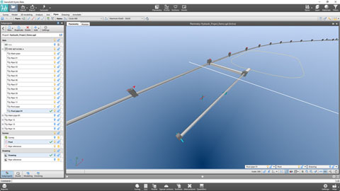
Rohrleitungsnetze mit SierraSoft Hydro
Beispiel für die Erstellung eines Rohrnetzes und die automatische Nummerierung (Video in Englisch)
Sehen Sie sich das Video an >
Anpassungen von Kanälen und Knotenpunkten mit SierraSoft Hydro
Beispiele für die Veränderung der Kanalachse und die Gestaltung von Knotenpunkten mit einem bestehenden Kanalnetz. (Video in Englisch)
Sehen Sie sich das Video an >
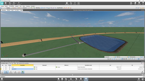
Berechnung der Massen mit SierraSoft Hydro
Beispiele für die Berechnung von Massen für Schnitte, für Modelle und für Einheiten mit der Erstellung von Informationsmodellen (Video in Englisch)
Sehen Sie sich das Video an >
Ausführungspläne mit SierraSoft Hydro
Datenausdrucke und Verwaltung von Planbeschriftungen und -blättern für die Erstellung von Zeichnungsunterlagen mit Anbindung an das Projektinformationsmodell (Video in Englisch)
Sehen Sie sich das Video an >
BIM-Software für die Straßen- und Autobahnplanung
SierraSoft Roads ist eine BIM-Software für die Planung von Verkehrswegen: Straßen, Autobahnen, Kreisverkehre, Abzweigungen, Kreuzungen, Ein- und Ausfahrten.
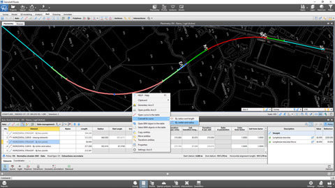
Planung eines Straßenverlaufs gemäß dem Regelwerk mit SierraSoft Roads
Beispiel für die Planung der Anordnung einer Achse nach dem Regelwerk (Video in Englisch)
Sehen Sie sich das Video an >
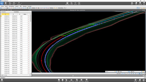
Achserzeugung und Ergebnisse mit SierraSoft Roads
Beispiel für die Erzeugung von Achsen, um den Lageplan des Projekts, das Straßenmodell, die Schnitte, die Massen und das Informationsmodell zu ermitteln (Video in Englisch)
Sehen Sie sich das Video an >
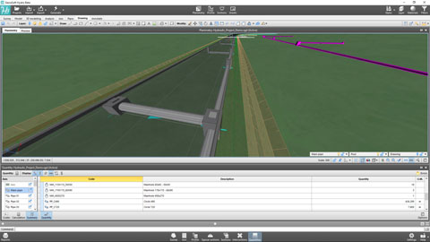
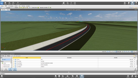
Berechnung der Massen mit SierraSoft Roads
Beispiele für die Berechnung von Massen für Schnitte, für Modelle und für Einheiten mit der Erstellung von Informationsmodellen (Video in Englisch)
Sehen Sie sich das Video an >
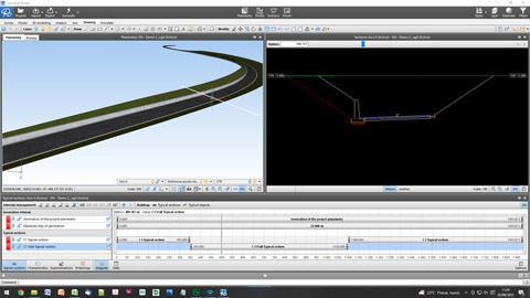
Anpassen der Trasse mit SierraSoft Roads
Beispiele für Änderungen in bestimmten Merkmalen der Achsen mit typischen Schnitten, typischen Regelquerschnitten, Achspolylinien und Profilen (Video in Englisch)
Sehen Sie sich das Video an >
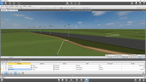
3D-Planung mit BIM und SierraSoft Roads
Beispiel einer 3D-Planung mit Smart-Polyline und Erstellung des finalen Modells (Video in Englisch)
Sehen Sie sich das Video an >
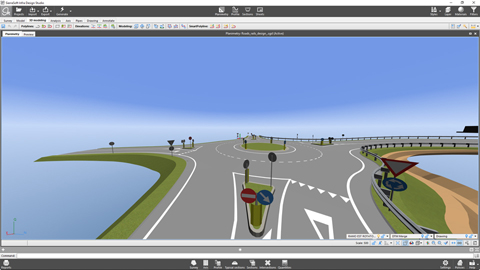
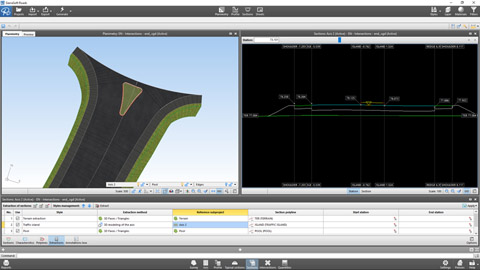
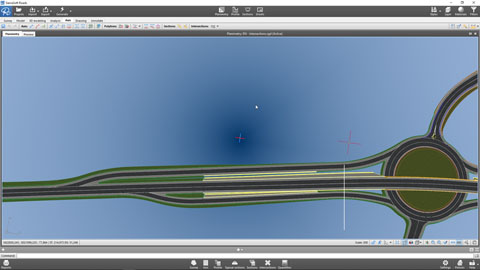
Verwaltung von Knotenpunkten im Rahmen von BIM mit SierraSoft Roads
Beispiel für die Verwaltung von niveaugleichen Knotenpunkten, niveaugleichen Kreisverkehren und Ein- und Ausfahrten (Video in Englisch)
Sehen Sie sich das Video an >
Pläne für BIM mit SierraSoft Roads
Datenausdrucke und Verwaltung von Planbeschriftungen und -blättern für die Erstellung von Zeichnungsunterlagen mit Anbindung an das Projektinformationsmodell (Video in Englisch)
Sehen Sie sich das Video an >
BIM-Software für die Eisenbahnplanung
SierraSoft Rails ist eine BIM-Software für die Planung von Eisenbahninfrastrukturen für niedrige und hohe Geschwindigkeiten, ein- und zweigleisig.
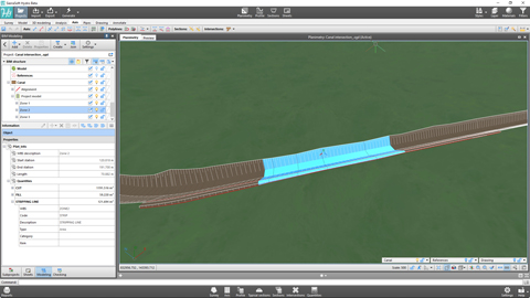
Planung einer Eisenbahntrasse gemäß dem Regelwerk mit SierraSoft Rails
Beispiel für die Planung der Anordnung einer Achse nach dem Regelwerk (Video in Englisch)
Sehen Sie sich das Video an >
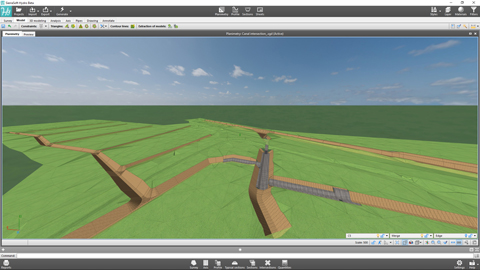
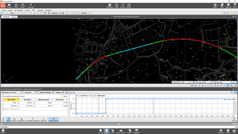
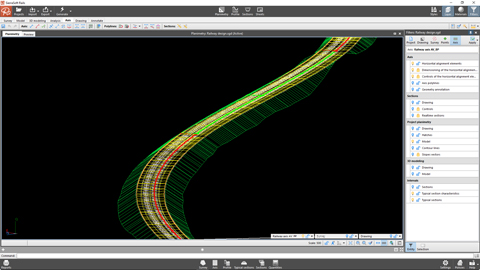
Achsgenerierung und Ergebnisse mit SierraSoft Rails
Beispiel für die Achsgenerierung, um den Lageplan des Projekts, das 3D-Modell, die Schnitte, die Massen und das Informationsmodell zu erhalten (Video in Englisch)
Sehen Sie sich das Video an >
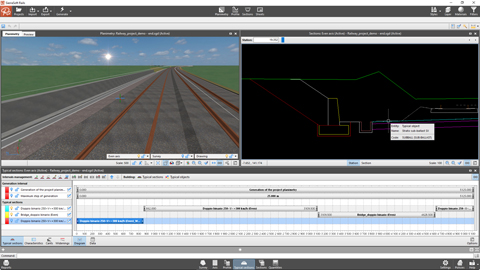
Anpassung der Achselemente mit SierraSoft Rails
Beispiele für Änderungen in bestimmten Merkmalen der Achsen mit typischen Schnitten, typischen Regelquerschnitten, Achspolylinien und Profilen (Video in Englisch)
Sehen Sie sich das Video an >
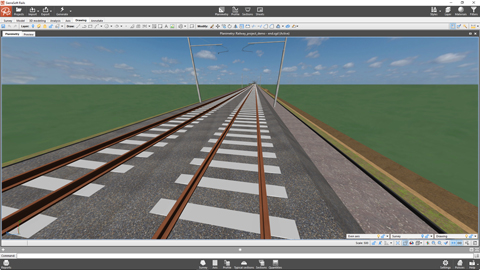
3D-Planung in BIM mit SierraSoft Rails
Beispiel einer 3D-Planung mit Smart-Polyline und Erstellung des finalen Modells (Video in Englisch)
Sehen Sie sich das Video an >
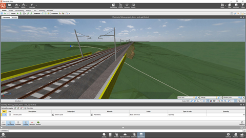
Berechnung der Massen mit SierraSoft Rails für BIM
Beispiele für die Berechnung von Massen für Schnitte, für Modelle und für Einheiten mit der Erstellung von Informationsmodellen (Video in Englisch)
Sehen Sie sich das Video an >
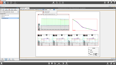
Zeichnungserstellung imit SierraSoft Rails für BIM
Datenausdrucke und Verwaltung von Planbeschriftungen und -blättern für die Erstellung von Zeichnungsunterlagen mit Anbindung an das Projektinformationsmodell (Video in Englisch)
Sehen Sie sich das Video an >